Action Plan for the Northern Abalone (Haliotis kamtschatkana) in Canada
Appendix IV: Impact Assessment Protocol for Works and Developments Potentially Affecting Abalone and Their Habitat
by
Joanne Lessard
Alan Campbell
Fisheries and Oceans Canada, Stock Assessment Division, Science Branch, Pacific Biological Station,
Nanaimo, B.C., V9T 6N7
Table of Content
- 1. Definitions
- 2. Background.
- 3. How to Determine Impact on Abalone.
- 4. Phase 1: Initial Survey.
- 5. Abalone Habitat
- 6. Phase 2: Transect Survey.
- 7. Control Site.
- 8. Phase 3: Monitoring Program – Plot Survey
- 9. Phase 4: Feedback
- 10. References
- Appendix A. Third party biologist requirements
- Appendix B. Field data sheet for the transect survey.
- Appendix C. Field data sheet for the plot survey.
- Appendix D. Dive Codes
- Appendix E. Database Field Descriptions
Definitions
3rd Party Biologist: an established independent third party biological consultant company or an independent third party biologist accredited with a university or college degree in a related biological science that has preferably formed an independent company under his/her own name with experience working with DFO in accomplishing biological research including surveys. Other requirements are outlined in Appendix A.
Abalone Habitat: description of physical and biological features of habitats where abalone are found; includes all abalone habitats as well as critical (not defined for abalone). See Section 5.
Control Site: location outside of the area of influence and within 1000m of the potentially impacted site to minimize differences in current and temperature regimes
Critical Habitat: the habitat that is necessary for the survival or recovery of a listed wildlife species that is identified as the species’ critical habitat in the recovery strategy or in an action plan for the species (as defined under SARA)
Impact: unless other wise stated (e.g. impact on habitat) in this document, for the sake of brevity, impact refers to the direct or indirect impacts of works and developments on abalone abundance and distribution only.
Initial Survey: See Section 4.
Monitoring Program: the plot survey repeated at least once a year.
Plot Survey: See Section 8.
Precautionary Approach: Set of measures taken to implement the Precautionary principle. A set of agreed cost-effective measures and actions, including future courses of action, which ensures prudent foresight, reduces or avoids risk to the resource, the environment, and the people, to the extent possible, taking explicitly into account existing uncertainties and the potential consequences of being wrong. (Garcia S.M. (1996) The precautionary approach to fisheries and its implications for fishery research, technology and management: An updated review. FAO Fish. Tech. Paper, 350.2: 1-76)
Recruitment: for this document, juvenile abalone with a shell length <70 mm.
SARA: Species at Risk Act
Site: proposed site, unless otherwise stated (e.g. control site).
SL: Shell length, the maximum measurement of an abalone shell.
Transect Survey: See Section 6.
2. Background
The provisions of SARA that were implemented on June 1, 2004 include:
- prohibitions on killing, harming, harassing, possessing, buying or selling an individual of a species listed as an extirpated species, an endangered species or a threatened species etc. (section 32).
- prohibitions on damaging or destroying residences of individuals (section 33).
- prohibitions on destroying the critical habitat of a listed endangered or threatened species or listed extirpated species (section 58).
- provisions for effective enforcement measures and significant penalties where needed to serve as a deterrent.
These prohibitions will apply to aquatic species that are listed under SARA as extirpated, endangered or threatened. There is a provision in SARA (section 73) that allows the competent minister (DFO for listed aquatic species) to authorise a person to engage in an activity that affects a listed wildlife species, its critical habitat or residence. However, this provision also includes a series of strict criteria that must be met prior to doing so.
Currently there is ample habitat available in BC for the northern abalone population. In general, abalone populations have declined; however, there has been no known significant reduction in available habitat. Therefore, habitat loss is not a major concern in the recovery of northern abalone at this time in comparison with the identified threats. Although good abalone habitat is not believed to be limiting, there may be certain habitat where juvenile survival is better, or where the reproducing adults contribute to a larger portion of the total recruitment. Identification of this key habitat is being included as part of the abalone research and rebuilding plans.
The abalone recovery strategy identified several knowledge gaps (Abalone Recovery Team 2002). The recovery strategy identified the need to clarify the extent of threat of works and developments on, in and under the water to northern abalone populations and habitat. The recovery strategy also identified the need for monitoring and regulation of projects to prevent losses to important spawning aggregations and maintain ecosystems in which abalone can recover. Once ‘critical habitat’ for northern abalone is defined (e.g., abalone beds or important spawning aggregations), specific criteria to protect it under the Fisheries Act and Regulations (1993) and SARA (2003) may be better developed and applied. Until then, it is recommended that the best science available be used, and where science is lacking that a precautionary approach be adopted in considering and approving location(s) for works and developments on, in, and under the water.
Determining impacts on a site by site basis is impractical and will not provide meaningful data as other factors may affect abalone populations. However, when all sites with abalone are combined it may be possible to determine the impact(s) if a proper scientific method is followed. It is the intention of the monitoring program described in Section 8 to evaluate what these impacts are. Given DFO abalone stock assessment limited budget, no large scale studies are planned to determine the impacts of works and developments on, in or under the water on abalone populations. Therefore, the proponents will have to either pay for a DFO certified 3rd party biologist and/or give money to DFO to carry out the work, which will include field survey, analysis and reporting.
This impact assessment protocol applies to any proposed works and developments where abalone habitat is present and the area affected will be larger than 20m2. The amount of abalone habitat necessary to trigger this protocol is arbitrary and is purposely small as the shape of the area impacted is important. For example, 20m2 distributed as a 1m vertical swath to a depth of 10m with a moderate slope is not equal to 20m wide 1m horizontal swath parallel to shore at 3m depth because abalone prefer shallow depths and more abalone preferred habitat is impacted in the second scenario. If abalone are present in a small area (i.e. <20m2) expected to be impacted, the individual abalone shall be relocated, under a SARA permit, to suitable abalone habitat nearby. The SARA permit will include the following conditions (some conditions may vary depending on the available abalone habitat nearby):
- The dive surveys of the area to be impacted must take place at night and search successive depth contours in a systematic and thorough manner.
- All abalone observed within the survey area must be removed from the substrate by hand only, with the assistance of a Pycnopodia helianthoides (sunflower sea star) if necessary; prying abalone from the substrate is not permitted;
- The shell length (to the nearest mm), depth located, substrate type and dominant algae species must be recorded for each abalone observed;
- The abalone must be relocated underwater to a location of cover in rocky subtidal habitat no deeper than 6m depth (chart datum) and a minimum of 50 metres away from the construction footprint; taking abalone from the water is not permitted;
- Plastic totes may be used to move the abalone underwater and abalone may be relocated in close proximity of another abalone to improve chance of spawning success;
- As a requirement to report information under this project, the authorized persons must submit a written record containing the following summary information:
- Dates in which relocation surveys took place;
- Number of abalone observed and relocated;
- Shell length, depth located, substrate type and dominant algae cover for each abalone observed;
- Overall perspective on the success or difficulties in conducting the work.
3. How to Determine Impact on Abalone
Except for surveyed sites, there is a general lack of data on abalone distribution and abundance throughout the BC coastline. Site specific information for proposed works and developments must be acquired before any decision can be made. In order to determine impacts of works and developments on abalone populations and make inference to their habitat, abalone will have to be present at some sites. Only abundance, and possibly distribution, data will be used to determine impacts in the short term (2-5 years) as other parameters of abalone population health are more difficult to measure (e.g. change in reproductive output, growth, disease incidence, etc.). Impacts may be determined by changes in density before and after the project is completed in conjunction with the continuous monitoring of control site(s) outside of the area of influence. For example, there may be a statistically significant changes (increases or decreases) in total abalone density within the site, but no change at the control site(s) or the total density does not change, but one of size category (juvenile, mature, etc.) becomes more dominant when compared with the control site(s). Observing changes in abalone spatial distribution will be more difficult unless some animals are uniquely identified (tagged), particularly if density decreases and few or no shells are recovered. Nevertheless, changes in depth distribution and aggregation will be possible under the proposed monitoring approach described in Section 8.
To obtain information necessary to make a decision on the site and evaluate impacts if approved, we recommend a four phased approach:
Phase 1: Initial Survey
- The site is assessed to determine the extent of abalone habitat present using nearshore swims. The abalone habitat is then mapped.
Phase 2: Transect Survey
- A quantitative survey is conducted to estimate abalone densities within the abalone habitat identified in Phase 1 as well as in an area outside the area of influence.
Phase 3: Monitoring program – Plot survey
- If the site is accepted and abalone are present, an intensive survey is conducted at 1-3 plots within the impacted site as well as within a control site, outside the area of influence.
Phase 4: Feed Back
- After 5 years, an analysis of abalone abundance and distribution data combining several sites of a given type of work or development should be completed to evaluate the impacts and determine if mitigation actions are required.
Each phase is described in detail in the sections below. We recommend that Phase 1 to 3, if not done by DFO staff, be completed by a certified 3rd party biologist (see Appendix A for requirements).
4. Phase 1: Initial Survey
The objectives of this phase are to (1) establish the area of Abalone Habitat present at the site, and (2) delineate these habitats on a chart. Although all habitats are important, for the purpose of this document, only abalone habitat is described in Section 5.
Site definition
The site is defined by using landmarks and geographic coordinates. The ‘site width’ is the linear distance between the two furthest points.
Nearshore-swims
Two divers swim (a few metres apart from each other) in a zigzag pattern (generally parallel to shore) between depths of 0-10 m chart datum. Very good notes need to be taken throughout the swim so that the GPS coordinates can be related to what was observed underwater. Habitat changes including changes in primary substrate (e.g., bedrock to boulders or sand), and algal community (e.g., from a Macrocystis to a Nereocystis kelp forest or understorey algae only), should be marked using one of two methods described below.
Method 1: Floats can be deployed at the edges of each change in habitat. The boat can then use a GPS to obtain the coordinates. Because the edges of habitats do not usually form a straight line, several floats need to be release to accurately map the habitats.
Method 2: One person is put on shore at a location where most of the surface water of the site would be visible and records his/her position using a portable GPS. Two divers swim throughout the site during several dives carrying a metal float. At a change in habitat, one of the divers pulls on the float several times while the other diver records the time, depth and other habitat information. Upon seeing the float bob at the surface, the shore person measures the distance to the float using a laser range finder and the magnetic bearing of the float using a compass and records the time which will be matched with the time recorded underwater.
Desired results
The end product of this phase should be a digital map with depth contours and the important habitats delineated. Although all habitats should be outlined, for the purpose of this document, only abalone habitat is described here in detail (see next section).
Data Management
The GPS shore positions are imported into ArcView 3.2 or another GIS software.
Method 1: The GPS positions from the boat are matched with the divers notes to digitize (create a polygon) abalone habitat.
Method 2: From the shore positions, the measured distances and bearings are plotted using an extension from Jenness Enterprises called “Distance & Azimuth tool”. Polygons delineating abalone habitat are created using the plotted positions.
The digital map, electronic file containing the GPS points and copies of the field notes must be sent to the Shellfish Data Unit, PBS, Nanaimo.
Decision rule for next step
If abalone habitat, as described in the next section, is present and the area of the abalone habitat is > 20m2, then the next phase is necessary to assess the abalone density at the site as well as in surrounding areas.
5. Abalone Habitat
Physical factors include:
- Primary Substrate: bedrock and/or boulders
- normal salinity (not low salinity as found close to river run off)
- Depth: ≤10m depth (datum)
- Good water exchange (tidal current or wave action present)
- Secondary Substrate: some cobble may be present and little or no gravel, sediment, sand, mud, or shell present.
Biological factors include:
- Presence of encrusting coralline algae (e.g. Lithothamnium)
- Presence of sea urchins Strongylocentrotus franciscanus and/or S. droebachiensis, Lithopoma (Astraea) gibberosa, sea stars.
- Presence of kelp in surrounding area (e.g., Nereocystis, Macrocystis, Pterygophora).
- Presence/absence of abalone
Physical and biological factors are listed in order of importance.
Phase 2: Transect survey
The objective of the transect survey is to get quantitative estimates of abalone density and distribution within the abalone habitat delineated in the initial survey (Phase 1). This is necessary to evaluate if the work or development proposal will be accepted based on the 0.1 abalone/m2 criteria (see “Decision Rules” this section). The method described in this section is identical to Lessard et al. (2002) with two exceptions: (1) the higher confidence interval is used for the density calculation, and (2) the population size is not calculated as it is unnecessary to evaluate the site. The 0.1 abalone/m2 threshold was originally based on the measurable short-term goal of the National Recovery Strategy (see “Background” section). Although, this threshold in the recovery strategy is for the size category ≥100 mm SL, the higher confidence interval of the mean is used here.
Transect survey(s) outside the area of influence is also necessary to assess possible control site(s). The transect survey at the control site(s) may be done after the transect survey at the proposed site is completed and the site is given approval to go ahead. However, to minimize seasonality effects, transect survey(s) at possible control sites should be conducted within a month, two at the most. For information on where the control site should be, see Section 7. Control Site.
Transect placement
Transect positions are marked on nautical charts before the survey begins. The positions are selected randomly using the ‘abalone habitat width’ defined as the linear distance between the two furthest points of the abalone habitat. Transects are perpendicular to the shoreline at these positions. If the abalone habitat is discontinuous, separated by large areas of unsuitable abalone habitat (e.g., area of sand), the process to select the transect positions is repeated for each area of abalone habitat. At least ten transects should be surveyed in each abalone habitat area. If the width of the abalone habitat is shorter than 300m, a lesser amount of transects may be considered.
Transect layout
The primary sampling unit is a transect, made up of a variable number of secondary units: quadrats. Each transect is one meter wide and variable in length, depending on the slope of the substrate. Prior to entering the water, a lead line, the transect, is laid perpendicular to the shore, from the boat. If this is not possible, because of thick kelp beds or other environmental factors, then the divers should sample along a compass bearing perpendicular to the shore. The compass bearing must be strictly followed to avoid possible bias in the density estimate(s). Transects begin at 10 m chart datum and extend all the way into the shore, or to the point where the surge makes it impossible for the divers to work effectively.
Underwater survey (Filling out the “Abalone Field Sheet - Transect” Appendix B)
The secondary sampling unit consists of a 1 m x 1 m square quadrat that is placed beside the transect, 1 m away to avoid the area potentially disturbed by the lead line placement. Divers flip the quadrat parallel to the transect line, from deep to shallow. One diver records the data while the other measure the abalone and flips the quadrat. In each quadrat, the recording diver writes down 1) the shell length (SL in mm) of each abalone, 2) the depth, 3) the time, 4) the substrate type, 5) the number of urchins, 6) the number and relative size of abalone predators (sunflower starfish, Dungeness and red rock crabs, octopus, etc.) and 7) the % cover and dominant species of algae. The % cover of all algae combined is recorded by category: 1) canopy (kelp taller than 2m), 2) understorey (algae between 15cm and 2m in height), 3) turf (erect algae less that 15cm in height) and 4) encrusting (carpet-like algae). The dominant algal species (1-2) are recorded for the first 3 categories only. Appendix D lists the substrate and algae species codes to be used. The measuring diver must exercise caution when measuring abalone to ensure that the longest shell length is measured and the abalone is returned right side up on the rocks outside and behind of the quadrat. In order to minimize habitat damage, algae are not to be removed. Boulders are not to be moved to search for cryptic abalone. Caution must be exercised to ensure that abalone in upcoming quadrats are not disturbed.
Where the transect length is greater than 20 m, only every second quadrat needs to be sampled completely. If transects are longer than 60 m, abalone and depth can be sampled every second quadrat, and substrate and algae cover can be sampled every fourth quadrat. The frequency of sampling must be written on the underwater sheet.
Analytical methods
Calculations are included here for information only. The analysis will be performed by DFO Stock Assessment.
For each site, the estimated mean density, ![]() (number/m2), of abalone is calculated as:
(number/m2), of abalone is calculated as:
 (1)
(1)
The standard error of the mean density, ses, is calculated as:
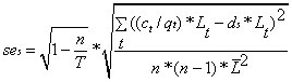 (2)
(2)
- where n is the number of transects,
- ct is the number of abalone counted in transect t,
- qt is the number of quadrats sampled in transect t,
- Lt is the length of transect t,
 is the mean transect length,
- T is the total possible number of transects that can be sampled in the surveyed area and is equal to the ‘abalone habitat width’.
- ct is the number of abalone counted in transect t,
This method accounts for the variable length of transects and for the variable proportion of quadrats surveyed along each transect.
To estimate the mean density (Equation 1) and standard error (Equation 2) for a specific size group (i) (i.e. ≥100 mm SL), the value ct is substituted with cti, the counts of size group i in transect t.
At each site, the higher 90% confidence intervals of the mean density (H90CI), for all sizes or for a particular size group (≥100 mm SL) of abalone, are calculated using bootstrapping (Davidson and Hinkley, 1997).
Data Management
All the data must be entered using the “Transect Data Entry” form in the Access database provided by DFO Stock Assessment. The fields that need to be filled on the field sheets and in the database are described in Appendix E. The original field data sheets as well as the electronic version in Access must be sent the Shellfish Data Unit, PBS, Nanaimo.
At PBS, a S-Plus script exists to analyze the data using the data directly from the database.
Decision rule for next phase
If the H90CI for all sizes is ≥0.1 abalone/m2, the site is automatically rejected. If the H90CI for all sizes is <0.1 abalone/m2, the responsibility of the decision to go ahead with permitting rests with the Habitat Management Program. If the site is accepted and an authorization is issued in accordance with section 35 of the Fisheries Act, the next phase is initiated.
Control Site
Proposed control site(s) should be outside of the area of influence and within 1000m of the impacted sites to minimize differences in current and temperature regimes. For aquaculture proposals, the area of influence is determined by DEPOMOD. The control site must be within abalone habitat as described in Section 5. In general, the control site should have the same relative exposure, current regime and habitat characteristics. For example, it would be unsuitable to have smooth bedrock substrate within the abalone portion of the impacted site and boulders at the control site. It may also be unsuitable to have the control ‘around the corner’ where exposure to wave action would be different.
Phase 3: Monitoring program – Plot Survey
The objective of this phase is to survey abalone within a small geographic area in order to calculate reliable density estimates with minimal variation. A density estimate with high precision is essential to detect impacts on abalone abundance as abalone density estimates have inherently high variance due to their aggregating behaviour. It is not rare to have standard deviations equal to or larger than the mean density estimates. For example, if the mean density estimate from the transect survey is 0.05 abalone/m2 with a pooled standard deviation of 0.025 abalone/m2, 34 samples would be necessary to detect a change in abundance of at least 50% with 95% confidence 80% of the time (17 impacted sites and 17 control sites). To increase precision, more plots can be placed in both the impacted and control sites; this would add a strata (high/low density areas) to the sampling design. In addition, more random transects can be added within each depth strata. The number of samples (transects) and strata can be determined using the transect survey results.
The plot survey is based on a stratified random sampling design. The current plot survey design is based on past survey results and builds on the Parks Canada and Haida Fisheries Program survey designs. Figure 1 gives a schematic diagram of the plot survey design. A better design would involve using the quadrats as the primary sampling unit and have each quadrat randomly placed within the plot. Strata (e.g. deep/shallow and/or high/low density areas) could also be used. However, the underwater logistics of such a design are impractical. The sampling design described below is for the minimum number of strata and samples required: one plot at each of the impacted and control sites with 2 depth strata in each plot and 10 or 8 transects for the shallow or deep reference lines, respectively.
Figure 1. Schematic view of the plot survey design. Numbers on the left side are depths in metres (datum).
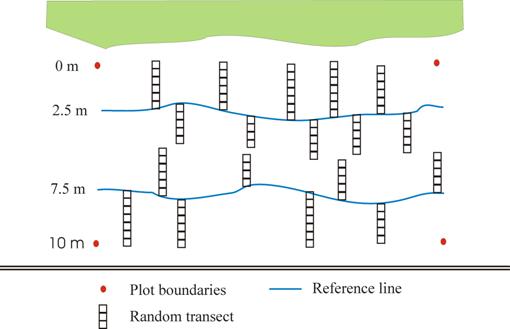
Reference line placement (in consultation with DFO Stock Assessment)
Two reference lines, 40m long each, are placed at 2.5m and at 7.5m below chart datum. The location of the reference lines are the middle of the 2 depth zones (0-5m and 6-10m) that are going to be sampled (the 2 strata in a stratified random sampling design). On each of the reference lines, several short perpendicular 1 m wide transects are surveyed, alternating on either side of the reference lines to minimize disturbance. The start location of each transect is chosen randomly prior to the start of the survey.
Choose 10 starting positions (out of 40 m) along the shallow reference line (2.5m) and 8 along the deep reference line (7.5m). Additionally, randomly choose the side of the transect where the first transect is placed and alternate thereafter (marked as “Start Down” or Start Up” on the field sheet).
Underwater survey (Filling out the “Abalone Field Sheet - Plot” Appendix C)
Each transect starts off the reference line at the randomly chosen location and the quadrat is flipped perpendicular to the reference line until the top, or bottom, of the depth zone is reached. No lead line is laid out for the random transects (a compass bearing can be taken, but this is not necessary as the transects are usually short, 4-8 quadrats long). One diver records the data while the other measures the abalone and flips the quadrat. In each quadrat, the recording diver writes down 1) the shell length (SL in mm) of each abalone, 2) the depth, 3) the time, 4) the substrate type, 5) the number of urchins, 6) the number and relative size of abalone predators (sunflower starfish, Dungeness and red rock crabs, octopus, etc.) and 7) the % cover and dominant species of algae. The % cover of all algae combined is recorded by category: 1) canopy (kelp taller than 2m), 2) understorey (algae between 5cm and 2m in height), 3) turf (erect algae less that 5cm in height) and 4) encrusting (carpet-like algae). The dominant algal species (1-2) are recorded for the first 3 categories only. The measuring diver must exercise caution when measuring abalone to ensure that the longest shell length is measured and the abalone is returned right side up on the rocks outside and behind of the quadrat. In order to minimize habitat damage, algae are not to be removed. Boulders are not to be moved to search for cryptic abalone. Caution must be exercised to ensure that abalone in upcoming quadrats are not disturbed. All quadrats are sampled completely. Once the transect is completed, the divers move to the random location and repeat the procedure until all locations have been completed within the depth strata.
Analytical methods
To calculate the mean and standard error within each strata a, the analysis is identical to the Transect Survey in Section 6.
For each site, the estimated mean density, ds (number/2), of abalone is calculated as:
ds = (1/N)∑nada (3)
The standard error of the site mean density, ses, is calculated as:
ses = (1/N)∑nasea (4)
where N is the total number of transects in all strata
na is the number of transects in strata a
da is the estimated mean density in strata a
sea is the estimated standard error of the mean in strata a
The data will probably not be normally distributed and a nonparametric test such as the Wilcoxon paired-sample test should be used to look at differences between control and impacted sites.
Data Management
All the data must be entered using the “Plot Data Entry” form in the Access database provided by DFO Stock Assessment. The fields that need to be filled on the field sheets and in the database are described in Appendix E. The original field data sheets as well as the electronic version in Access must be sent to the Shellfish Data Unit, PBS, Nanaimo.
Decision rule for next phase
Once the monitoring is initiated at more than one site, the next phase should be instigated after 2-5 years depending on the extent of the changes. For example, if densities decrease at all impacted sites, but not at the control sites, by >50% within 2 years, then Phase 4 should be initiated.
Phase 4: Feedback
In phase 4 all monitoring data for a given type of work or development are pooled to determine overall impacts of this given type of work or development on abalone populations. Due to natural variation in abalone density and the low initial densities at approved sites (<0.1abalone/m2), a small change in abundance or distribution will be difficult to detect. Detecting changes less than 50% is therefore impractical because of the high variance and a much larger number of samples would be required.
Because of the possible implications of such an analysis, the results should be presented at PSARC.
References
Davidson, A.C., and Hinkley, D.V.. 1997. Bootstrap Methods and their Application. Cambridge University Press, Cambridge. 578 p.
Lessard, J, Campbell, A, and Hajas, W. 2002. Survey protocol for the removal of allowable numbers of northern abalone, Haliotis kamtschatkana, for use as broodstock in aquaculture in British Columbia. CSAS 2002/126: 41 p.
Sloan, N.A., and Breen, P.A.. 1988. Northern abalone, Haliotis kamtschatkana, in British Columbia: fisheries and synopsis of life history information. Can. Spec. Public. Fish. Aquat. Sci. 103: 46 p.
Appendix A. Third party biologist requirements
The minimum requirements for biological expertise for an independent third party biologist to conduct abalone surveys are:
an established independent third party biological consultant company with experience working with DFO in accomplishing biological research including surveys; or
an independent third party biologist accredited with a university or college degree in a related biological science that has preferably formed an independent company under their own name and has experience working with DFO in accomplishing biological research including surveys.
And
meets a reference check for experience, competency, and demonstrated independent ‘arms length’ work experience;
And
has passed a training session with DFO-Stock Assessment Division on conducting abalone surveys, including data collection and reporting. Training will be given by DFO-Stock Assessment Division and may be expected to include dive surveying.
And
SCUBA dive certification, meeting WCB requirements
And
bonded (to ensure confidentiality)
And
knowledge of common algae, invertebrates and fish species.
And
has access to Microsoft Access database software
Appendix B. Field data sheet for the transect survey
See Appendix E for field descriptions.
_______________________________________________________________________________
Abalone Field Sheet - Transect Page ____ of _____
Site Name:_____________ File number:_____________ Date:_____________
Measurer: _____________ Recorder: ____________Time in:_____________
LAT:_____________ LONG:_____________ Direction (bearing in °):_____________
Transect number:_____________ Quadrat Frequency:_____________
| Quad | Depth |
Time |
Substrate |
Abalone Shell Length |
Urchin |
Predators |
Canopy |
Understory |
Turf |
En |
|---|---|---|---|---|---|---|---|---|---|---|
# |
ft. |
|
|
(mm) |
Count |
|
|
|
|
% |
|
|
|
|
|
|
|
|
|
|
|
|
|
|
|
|
|
|
|
|
|
|
|
|
|
|
|
|
|
|
|
|
|
|
|
|
|
|
|
|
|
|
|
|
|
|
|
|
|
|
|
|
|
|
|
|
|
|
|
|
|
|
|
|
|
|
|
|
|
|
|
|
|
|
|
|
|
|
|
|
|
|
|
|
|
|
|
|
|
|
|
|
|
|
|
|
|
|
|
|
|
|
|
|
|
|
|
|
|
|
|
|
|
|
|
|
|
|
|
|
|
|
|
|
|
|
|
|
|
|
|
|
|
|
|
|
|
|
|
|
|
|
|
|
|
|
|
|
|
|
|
|
|
|
Substrate codes: 1 bedrock smooth 3 boulders 5 gravel 7 sand 9 mud
2 bedrock crevices 4 cobble 6 pea gravel 8 shell
Appendix C. Field data sheet for the plot survey
note: Numbers/text in bold in the heading section of the field sheet are chosen randomly for each reference line for each period surveyed.
See Appendix E for field descriptions.
_____________________________________________________________________
Abalone Field Sheet - Plot Page ____ of _____
Site Name:_____________ File number:_____________Date:_____________
Measurer: _____________Recorder:_____________Time in:_____________
LAT:_____________LONG:_____________Direction (bearing in °):_____________
Reference Line:_____________(shallow or deep) Plot number:_____________
Transect start locations: 2, 6, 13, 19, 21, 25, 31, 32, 34, 38 Start Down
Tide height (height@time):________________________________________
| Quad | Depth |
Time |
Substrate |
Abalone Shell Length |
Urchin |
Predators |
Canopy |
Understory |
Turf |
En |
|---|---|---|---|---|---|---|---|---|---|---|
# |
ft. |
|
|
(mm) |
Count |
|
|
|
|
% |
|
|
|
|
|
|
|
|
|
|
|
|
|
|
|
|
|
|
|
|
|
|
|
|
|
|
|
|
|
|
|
|
|
|
|
|
|
|
|
|
|
|
|
|
|
|
|
|
|
|
|
|
|
|
|
|
|
|
|
|
|
|
|
|
|
|
|
|
|
|
|
|
|
|
|
|
|
|
|
|
|
|
|
|
|
|
|
|
|
|
|
|
|
|
|
|
|
|
|
|
|
|
|
|
|
|
|
|
|
|
|
|
|
|
|
|
|
|
|
|
|
|
|
|
|
|
|
|
|
|
|
|
|
|
|
|
|
|
|
|
|
|
|
|
|
|
|
|
|
|
|
|
|
|
Substrate codes: 1 bedrock smooth 3 boulders 5 gravel 7 sand 9 mud
2 bedrock crevices 4 cobble 6 pea gravel 8 shell
Appendix D. Dive Codes
| Code | Substrate |
|---|---|
1 |
Bedrock - smooth |
2 |
Bedrock - crevices |
3 |
Boulders (rock bigger than a basketball) |
4 |
Cobble (basketball down to 3 inches) |
5 |
Gravel (3 inches down to 3/4 inch) |
6 |
Pea gravel (3/4 inch down to 1/8 inch) |
7 |
Sand |
8 |
Shell |
9 |
Mud |
Code |
Species |
|---|---|
AA |
Alaria nana |
AB |
Agarum cribosum |
AC |
Articulated corallines |
AF |
Agarum fimbriatum |
AG |
Agarum sp |
AL |
Alaria sp |
AM |
Alaria marginata |
BB |
brown branched |
BF |
brown foliose |
BH |
brown filamentous |
CA |
Callophyllis sp |
CF |
Codium fragile |
CN |
Constantinea sp. |
CO |
Costaria costata |
CR |
Cryptopleura sp |
CS |
Codium setchellii |
CY |
Cymathere triplicata |
DB |
Dictyota binghamiae |
DE |
Desmarestia sp |
DF |
Desmarestia foliacea |
DL |
Desmarestia ligulata |
DU |
Desmarestia munda |
DR |
drift algae |
DS |
Delesseria sp. |
DV |
Desmarestia viridis |
EG |
Egregia menziesii |
EI |
Eisenia arborea |
EN |
encrusting algae |
ET |
Enteromorpha sp |
FU |
Fucus gardneri |
GA |
Green Algae |
GB |
green branched |
GE |
Gelidium sp |
GF |
green foliose |
GG |
eelgrass & surfgrass |
GH |
green filamentous |
GI |
Gigartina sp |
GR |
Gracilaria pacifica |
GS |
Gastroclonium subarticulatum |
HA |
Halosaccion glandiforme |
HE |
Hedophyllum sessile |
IR |
Iridea sp |
KK |
Kelp |
LA |
Laminaria sp |
LB |
Laminaria bongardiana |
LE |
Leathesia difformis |
LO |
Lessoniopsis littoralis |
LR |
Laurentia spectabilis |
LS |
Laminaria saccharina |
LT |
Laminaria setchellii |
MA |
Macrocystis integrifolia |
MI |
Microcladia sp |
NO |
No Algae Present |
NT |
Nereocystis luetkeana |
OD |
Odonthalia sp |
PH |
Phyllospadix sp |
PL |
Pleurophycus gardneri |
PO |
Porphyra sp |
PR |
Prionitis sp |
PT |
Pterygophora californica |
PV |
Pelvetiopsis sp. |
RB |
red branched |
RF |
red foliose |
RH |
red filamentous |
SA |
Sargassum muticum |
UL |
Ulva sp, Monostroma sp or Ulvaria sp |
UN |
Unknown |
ZO |
Zostera sp |
Appendix E. Database Field Descriptions
| Field Name | Description |
|---|---|
Site Name |
The name of the proposed tenure as stated on the application |
File Number |
File number of the application *if available |
Date |
YYMMDD |
Measurer |
The name of the diver measuring and counting |
Recorder |
The name of the diver recording |
Time In |
The time (hh:mm) the diver leaves the surface *note: do not round to 5 mins. |
Time Out |
The time (hh:mm) the diver reaches the surface |
LAT |
Latitude of site in degrees and decimal minutes |
LONG |
Longitude of site in degrees and decimal minutes |
Direction (bearing in º) |
The bearing in which the transect is laid, in degrees |
Reference Line |
(shallow or deep) |
Plot Number |
Number assigned to the plot |
Transect start locations |
Randomly selected points along the transect to lay reference lines |
Start |
The direction from the main transect line to start the first quadrat, either shallow or deep |
Tide height (height @time) |
Several tide height to add to maximum depth to reach for strata (e.g., 4.5ft@10:30, 5ft@11:00, etc) |
Quad# |
The number of the quadrat being sampled |
Depth (ft) |
The gauge depth, in feet, for the quadrat being sampled |
Time |
The time (hh:mm) at which the diver was in that quadrat |
Substrate |
up to three codes for the most prominent substrate types in that quadrat (see sheet for codes) |
Abalone Shell length (mm) |
The measured shell length in mm of each abalone measured |
Urchin Count |
The number of urchins counted in that quadrat |
Predators |
(count/size/species) eg. 2MPy = 2 medium Pycnopodia |
Canopy |
% and species of the most dominant canopy species (kelp taller than 2m) (e.g., 50 MA = 50% Macrocystis) |
Understory |
% and species of the most dominant understorey species (algae between 5cm and 2m in height) |
Turf |
% and species of the most dominant turf species (erect algae less that 5cm in height) |
En% |
% (only) of cover of encrusting (carpet-like algae) |