Scientific Assessment to Inform the Identification of Critical Habitat for Woodland Caribou (Rangifer tarandus caribou), Boreal Population, in Canada - 2011 Update
Previous Page | Table of Contents | Next Page
Key Findings
The information and analyses presented in this report address limitations identified with implementation of the work presented in the 2008 Scientific Review. However, neither the approach nor the results of this assessment represent a fundamental shift from the 2008 Science Review conclusion that range is the appropriate geographic delineation for critical habitat description. Further, the amount of total disturbance within a range remains the primary criteria for identifying critical habitat to meet a goal of self-sustaining local populations of caribou.
While improved data would enhance our understanding and address outstanding
uncertainties, this report concludes that sufficient information exists to support a
scientifically-grounded assessment of critical habitat for populations of boreal caribou
across Canada, and provides a scientific basis to inform critical habitat identifcation for
each of the 57 identified ranges that comprise the full extent of occurrence of boreal caribou in
Canada.
Highlights of the application of the conceptual framework and associated analyses supporting this 2011 assessment include:
- Nearly 70% of the variation in caribou recruitment across twenty-four study areas spanning the full range of boreal caribou distribution and range condition in Canada was explained by a single composite measure of total disturbance (fire + buffered anthropogenic), most of which could be attributed to the negative effects of anthropogenic disturbance. Little statistical support was found for distinguishing different types of anthropogenic disturbances (e.g., linear and polygonal types). However, supporting analyses of a range of buffer widths demonstrated that a 500 m buffer on anthropogenic disturbance provided an appropriate, minimum approximation of the zone of influence of these features on caribou demography.
- Of the 57 identified boreal caribou ranges in Canada, 17 (30%) were assessed in the "self-sustaining" (SS) category, 7 (12%) in the "not self-sustaining/self-sustaining" (NSS/SS) category, and 33 (58%) in the "not self-sustaining" (NSS) category (Executive Summary Figure 1). Through the integrated risk assessment, these designations were refined to five likelihood categories ranging from very likely (SS) to very unlikely (NSS) with respect to the probability that current conditions would support a self-sustaining boreal caribou population.
Executive Summary Figure 1. Integrated risk assessment for boreal caribou ranges in Canada.
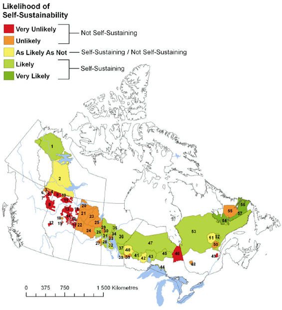
Range ID |
Range |
Range Type |
|---|---|---|
1 |
Northwest Territories North |
LP |
2 |
Northwest Territories South |
LP |
3 |
Maxhamish |
LP |
4 |
Calendar |
LP |
5 |
Snake-Sahtahneh |
LP |
6 |
Parker |
LP |
7 |
Prophet |
LP |
8 |
Chinchaga |
LP |
9 |
Bistcho |
LP |
10 |
Yates |
LP |
11 |
Caribou Mountains |
LP |
12 |
Little Smoky |
LP |
13 |
Red Earth |
LP |
14 |
West Side Athabasca River (WSAR) |
LP |
15 |
Richardson |
LP |
16 |
East Side Athabasca River (ESAR) |
LP |
17 |
Cold Lake |
LP |
18 |
Nipisi |
LP |
19 |
Slave Lake |
LP |
20 |
Davy-Athabasca |
CU |
21 |
Clearwater |
CU |
22 |
Primrose-Cold Lake |
CU |
23 |
Highrock-Key |
CU |
24 |
Smoothstone-Wapawekka |
CU |
25 |
Steephill-Foster |
CU |
26 |
Suggi-Amisk-Kississing |
CU |
27 |
Pasquia-Bog |
CU |
28 |
The Bog |
ICU |
29 |
Kississing |
ICU |
29 |
Kississing |
ICU |
30 |
Naosap |
ICU |
31 |
Reed |
ICU |
32 |
North Interlake |
ICU |
33 |
William Lake |
ICU |
34 |
Wabowden |
ICU |
35 |
Wapisu |
ICU |
36 |
Manitoba |
CU |
37 |
Atikaki-Berens |
ICU |
38 |
Owl-Flinstone |
LP |
39 |
Sydney |
ICU |
40 |
Berens |
ICU |
41 |
Churchill |
ICU |
42 |
Brightsand |
ICU |
43 |
Nipigon |
LP |
44 |
Coastal |
CU |
45 |
Pagwachuan |
ICU |
46 |
Kesagami |
ICU |
47 |
Far North |
CU |
48 |
Val d’Or |
LP |
49 |
Charlevoix |
LP |
50 |
Pipmuacan |
ICU |
51 |
Manouane |
ICU |
52 |
Manicouagan |
ICU |
53 |
Quebec |
CU |
54 |
Lac Joseph |
LP |
55 |
Red Wine Mountain |
LP |
56 |
Mealy Mountain |
LP |
57 |
Labrador |
CU |
LP - Local Population
CU - Conservation Unit
ICU - Improved Conservation Unit
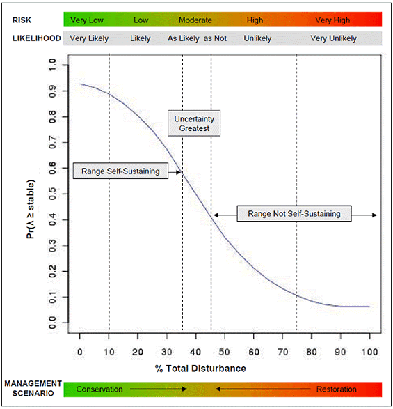
- Range-specific disturbance-based management thresholds can be derived from a generalized disturbance-population growth function in conjunction with range-specific information (Executive Summary Figure 2). A methodology was developed to extend the critical habitat description for consideration of disturbance-based management thresholds when acceptable risks are defined by managers. A core component of the methodology is a disturbance-based population growth function that can be used in conjunction with range specific information to derive range specific disturbance thresholds. Examples of the application of the methodology to derive range-specific disturbance thresholds are presented.
Executive Summary Figure 2. The disturbance-based population growth function used in conjunction with range-specific information to derive range-specific management thresholds once an acceptable level of risk by managers has been specified.
In addition to these highlights, several important observations related to the availability of information emerged, and recommendations related to these are advanced.
- Most boreal caribou ranges in Canada have not been fully described owing
to a lack of standardized animal location data and poor understanding of
movement within and between ranges. While a total of 57 ranges are still currently recognized by jurisdictions in Canada, changes to the delineation of boreal caribou ranges have been made since the 2008 Scientific Review, by various jurisdictions, based on different criteria. The issue of appropriate delineation of trans-boundary ranges remains unresolved. Addressing the need for more animal location and movement information, greater inter-jurisdictional collaboration, and a standardized approach to range delineation are important requirements to adequately and consistently describe ranges for local populations of boreal caribou throughout their current distribution, and support continuous improvement of critical habitat description over time.
- Demographic data are lacking for many boreal caribou ranges in Canada. Monitoring and assessment programs to provide data on population size, population trend, recruitment and adult mortality are required to improve understanding of factors affecting boreal caribou survival and recovery, increase certainty in assessment results, and to monitor response of populations to recovery actions and assess progress towards meeting the population and distribution objectives for boreal caribou across Canada. The need to acquire demographic data for many boreal caribou ranges should not be equated with a statement that insufficient knowledge exists for the identification of critical habitat for boreal caribou in Canada, but rather embraced as part of an adaptive management cycle designed to improve certainty in management strategies necessary to achieve the desired outcome of self-sustaining boreal caribou populations over time.
In conclusion, the breadth of information and knowledge compiled for this assessment exemplifies the comprehensive nature of, and interrelationships between, types of evidence available to provide a scientifically-based description of critical habitat for informing recovery planning for boreal caribou. Significant advances were made to the conceptual and methodological design during this assessment to address some key uncertainties or limitations identified in the 2008 Scientific Review. These advances improved the robustness of the results with respect to providing a scientific description of critical habitat for boreal caribou across Canada.